
Fichier:Evariste Huc carte voyage.jpg

Taille de cet aperçu : 764 × 600 pixels. Autres résolutions : 306 × 240 pixels | 612 × 480 pixels | 978 × 768 pixels | 1 280 × 1 005 pixels | 2 560 × 2 010 pixels | 3 559 × 2 794 pixels.
Fichier d’origine (3 559 × 2 794 pixels, taille du fichier : 2,1 Mio, type MIME : image/jpeg)
Description
| Description |
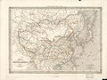
English: An unfocused copy of Dufour's 1840 "Map of China and Its Tributary States", used in Huc's 1850 Remembrances of a Voyage in Tartary, Tibet, and China during the Years 1844, 1845, and 1846 with a dark line tracing the route of Huc and his fellow missionary Joseph Gabet. Note that the eastern dark line is Dufour's line tracing the Grand Canal and not Huc's route; the northeastern point beginning his route is also misplaced. Both were corrected for the 1853 2nd ed.
The Yellow River is still shown following its lower course from before the massive floods of the 1850s. Shanghai is entirely omitted as less important than Hangzhou (Hang-tcheou), Suzhou (Sou-tcheou), and Songjiang (Song-kiang, entirely misplaced to the north bank of the Yangtze). Français : Carte de la Chine et des États-Tributaires par A. H. Dufour. Carte hors-texte de la Chine par A. H. Dufour, 1840, trajet du voyage ajouté. |
| Date | |
| Source | Évariste Régis Huc's 1850 Souvenirs d'un Voyage dans la Tartarie, le Thibet et la Chine pendant les Années 1844, 1845, et 1846. Another scan of the same map is available (with zoom) at Gallica, hosted by the French National Library. |
| Auteur | Auguste-Henri Dufour |
| Autres versions |
|


Conditions d’utilisation
|
Ceci est une reproduction photographique fidèle d'une œuvre d'art originale en deux dimensions. L'œuvre d'art elle-même est dans le domaine public pour la raison suivante :
La position officielle de la Fondation Wikimedia est que « les représentations fidèles des œuvres d'art du domaine public en deux dimensions sont dans le domaine public et les exigences contraires sont une attaque contre le concept même de domaine public ». Pour plus de détails, voir Commons:Quand utiliser le bandeau PD-Art.
Cette reproduction photographique est donc également considérée comme étant élevée dans le domaine public. Merci de noter qu'en fonction des lois locales, la réutilisation de ce contenu peut être interdite ou restreinte dans votre juridiction. Voyez Commons:Reuse of PD-Art photographs. | ||||
Historique du fichier
Cliquer sur une date et heure pour voir le fichier tel qu'il était à ce moment-là.
| Date et heure | Vignette | Dimensions | Utilisateur | Commentaire | |
|---|---|---|---|---|---|
| actuel | 17 août 2012 à 06:35 | | 3 559 × 2 794 (2,1 Mio) | Wuyouyuan | Carte redressée, et légèrement éclaircie pour une meilleure lisibilité. Avec GIMP. |
| 17 août 2012 à 05:41 |  | 3 631 × 2 859 (5,47 Mio) | Wuyouyuan |
Utilisation du fichier
Aucune page n’utilise ce fichier.