
Fichier:Evariste Huc carte voyage clear.png

Fichier d’origine (903 × 734 pixels, taille du fichier : 549 kio, type MIME : image/png)
Description
| Description |
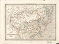
English: A clear version of a small French National Library scan of Dufour's 1840 "Map of China and Its Tributary States", used in Huc's 1853 2nd edition of his Remembrances of a Voyage in Tartary, Tibet, and China during the Years 1844, 1845, and 1846 with a dark line tracing the route of Huc and his fellow missionary Joseph Gabet. Note that this line is correct and includes his sea voyages, as opposed to the erroneous route traced in the 1st edition which confused Huc's route with Dufour's illustration of the Grand Canal. The Yellow River is still shown following its lower course from before the massive floods of the 1850s. Shanghai is entirely omitted as less important than Hangzhou (Hang-tcheou), Suzhou (Sou-tcheou), and Songjiang (Song-kiang, entirely misplaced to the north bank of the Yangtze). Some important places along Huc's route have been marked in the map and noted in a legend at the bottom of the page. Note that Huc & Gabet did not carry Dufour's map but one of those printed by Andriveau-Goujon like this. |
| Date | |
| Source | Souvenirs d'un Voyage dans la Tartarie, le Thibet, et la Chine pendant les Années 1844, 1845, et 1846, 2nd ed., Vol. I, p. 4. |
| Auteur | Unclear, from an original map by Auguste-Henri Dufour |
| Autres versions |
|


Conditions d’utilisation
|
Cette œuvre est également dans le domaine public dans tous les pays pour lesquels le droit d’auteur a une durée de vie de 70 ans ou moins après la mort de l’auteur. Cette œuvre est dans le domaine public aux États-Unis car elle a été publiée avant le 1er janvier 1929. | |
| Ce fichier a été identifié comme étant exempt de restrictions connues liées au droit d’auteur, y compris tous les droits connexes et voisins. | |
| Cette œuvre est dérivée d'une œuvre placée initialement dans le domaine public. Elle a été modifiée et/ou améliorée par manipulation informatique. Cette œuvre a été subséquemment publiée (ou bien est par la présente placée) dans le domaine public par son auteur, LlywelynII. Ceci s'applique dans le monde entier. Dans certains pays, ceci peut ne pas être possible ; dans ce cas :
|
Historique du fichier
Cliquer sur une date et heure pour voir le fichier tel qu'il était à ce moment-là.
| Date et heure | Vignette | Dimensions | Utilisateur | Commentaire | |
|---|---|---|---|---|---|
| actuel | 30 juillet 2019 à 03:51 | | 903 × 734 (549 kio) | LlywelynII | User created page with UploadWizard |
Utilisation du fichier
Les 2 pages suivantes utilisent ce fichier :
Usage global du fichier
Les autres wikis suivants utilisent ce fichier :
- Utilisation sur en.wikipedia.org
- Utilisation sur fr.wikipedia.org
- Utilisation sur ro.wikipedia.org
- Utilisation sur ru.wikipedia.org