
Fichier:Arabian Plate showing general tectonic and structural features, Infracambrian rift salt basins, and oil and gas fields of Central Arabia and North Gulf area.svg

Taille de cet aperçu PNG pour ce fichier SVG : 653 × 469 pixels. Autres résolutions : 320 × 230 pixels | 640 × 460 pixels | 1 024 × 735 pixels | 1 280 × 919 pixels | 2 560 × 1 839 pixels.
Fichier d’origine (Fichier SVG, nominalement de 653 × 469 pixels, taille : 76 kio)
Description
| Description |
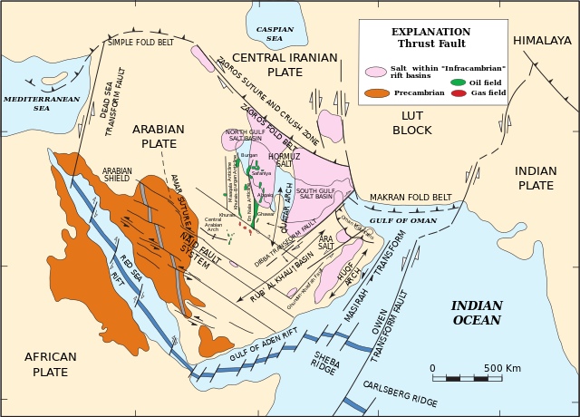
English: Arabian Plate showing general tectonic and structural features, Infracambrian rift salt basins, and oil and gas fields of Central Arabia and North Gulf area |
| Date | |
| Source | Pollastro, R.M. (2003) "Total Petroleum Systems of the Paleozoic and Jurassic, Greater Ghawar Uplift and Adjoining Provinces of Central Saudi Arabia and Northern Arabian-Persian Gulf", U.S. Geological Survey Bulletin 2202-H. https://pubs.usgs.gov/bul/b2202-h/b2202-h.pdf, page 14. |
| Auteur | Richard M. Pollastro |
Conditions d’utilisation
Cette image est placée dans le domaine public parce qu'elle contient des éléments issus de l'United States Geological Survey, une agence du Département de l'Intérieur des États-Unis. Pour plus d'information, consultez la politique officielle de copyright de l'USGS (en anglais)
|
Historique du fichier
Cliquer sur une date et heure pour voir le fichier tel qu'il était à ce moment-là.
| Date et heure | Vignette | Dimensions | Utilisateur | Commentaire | |
|---|---|---|---|---|---|
| actuel | 21 mars 2023 à 22:03 | | 653 × 469 (76 kio) | Sette-quattro | texts as objects |
| 10 mars 2023 à 13:53 |  | 512 × 396 (289 kio) | Sette-quattro | Uploaded a work by https://pubs.usgs.gov/bul/b2202-h/b2202-h.pdf from https://pubs.usgs.gov/bul/b2202-h/b2202-h.pdf with UploadWizard |
Utilisation du fichier
Aucune page n’utilise ce fichier.
Usage global du fichier
Les autres wikis suivants utilisent ce fichier :
- Utilisation sur de.wikipedia.org
- Utilisation sur en.wikipedia.org