
Fichier:Persian Empire, 490 BC.png
Taille de cet aperçu : 800 × 577 pixels. Autres résolutions : 320 × 231 pixels | 640 × 461 pixels | 946 × 682 pixels.
Fichier d’origine (946 × 682 pixels, taille du fichier : 159 kio, type MIME : image/png)
Description
| Description |
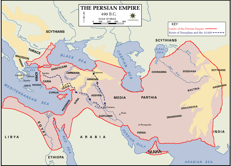
 English: Persian Empire, 490 BC, showing route of Cyrus the Younger, Xenophon and the 10.000.
Legends:
|
| Date | |
| Source | The Department of History - United States Military Academy |
| Auteur | DHUSMA |
| Autorisation (Réutilisation de ce fichier) |
In the public domain as original works of the United States federal government and/or military |
| Autres versions | For a version of this image altered to display better in Wikipedia articles (converted to PNG format, slightly cropped in File:Persian Empire, 490 BC.gif) y Italian version. |

|
Cette image (de type historical map) devrait être recréée dans un format vectoriel, en tant que fichier SVG. Cela offrirait plusieurs avantages : voir Commons:Media for cleanup pour plus d'informations. Si une version SVG de cette image est déjà disponible, merci de bien vouloir l'envoyer. Après cela, remplacez ce modèle par {{vector version available|nouveau nom d'image.svg}}.
|
Conditions d’utilisation
Ce média est dans le domaine public des États-Unis d’Amérique car son auteur est l’administration américaine comme précisé dans le code fédéral au Titre 17, Chapitre 1, Section 105. Pour en savoir plus : droit d’auteur.
Attention : Ceci ne concerne que le travail du Gouvernement Fédéral et pas celui des États, ou d’une autre subdivision géographique ou politique du pays.
|
 | |
| Ce fichier a été identifié comme étant exempt de restrictions connues liées au droit d’auteur, y compris tous les droits connexes et voisins. | ||
Historique du fichier
Cliquer sur une date et heure pour voir le fichier tel qu'il était à ce moment-là.
| Date et heure | Vignette | Dimensions | Utilisateur | Commentaire | |
|---|---|---|---|---|---|
| actuel | 2 août 2015 à 02:11 | | 946 × 682 (159 kio) | History of Persia | Achaemenid Arabia. see wikipedia article about achaemenid arabia |
| 11 avril 2013 à 11:21 |  | 942 × 684 (64 kio) | HistoryofIran | {{subst:Upload marker added by en.wp UW}} {{Information |Description = {{en|Added another region named Maka, it was listen on the Behistun inscription as part of the Achaemenid Empire.}} |Source = https://en.wikipedia.org/wiki/File:Persian_Empire,_490_... | |
| 10 avril 2013 à 19:21 |  | 942 × 684 (64 kio) | HistoryofIran | Changed where Chorasmia was written, it was much closer to the Aral sea. | |
| 10 avril 2013 à 19:19 |  | 942 × 684 (64 kio) | HistoryofIran | Added a more accurate map. | |
| 7 décembre 2012 à 22:55 |  | 942 × 684 (64 kio) | Geagea | Colchis and Caucasian Iberia. Not Georgia. | |
| 25 novembre 2012 à 16:24 |  | 942 × 684 (97 kio) | SilvioRusso | correction | |
| 27 août 2009 à 00:49 |  | 942 × 684 (64 kio) | AnonMoos | Version of File:Persian Empire, 490 BC.gif altered to display better in Wikipedia articles (converted to PNG format, slightly cropped). == Summary == ; Description : Persian Empire, 490 BC ; Author/Source : [http://www.dean.usma.edu/history/ The Depa |
Utilisation du fichier
Aucune page n’utilise ce fichier.
Usage global du fichier
Les autres wikis suivants utilisent ce fichier :
- Utilisation sur ast.wikipedia.org
- Utilisation sur bg.wikipedia.org
- Utilisation sur cs.wikipedia.org
- Utilisation sur da.wikipedia.org
- Utilisation sur el.wikipedia.org
- Utilisation sur en.wikipedia.org
- Utilisation sur fa.wikipedia.org
- Utilisation sur fr.wikipedia.org
- Utilisation sur fy.wikipedia.org
- Utilisation sur hr.wikipedia.org
- Utilisation sur hy.wikipedia.org
- Utilisation sur id.wikipedia.org
- Utilisation sur it.wikipedia.org
- Utilisation sur ko.wikipedia.org
- Utilisation sur ku.wikipedia.org
- Utilisation sur la.wikipedia.org
- Utilisation sur nl.wikipedia.org
- Utilisation sur no.wikipedia.org
- Utilisation sur pnb.wikipedia.org
- Utilisation sur pnt.wikipedia.org
- Utilisation sur ro.wikipedia.org
- Utilisation sur ru.wikipedia.org
- Utilisation sur sh.wikipedia.org
- Utilisation sur sr.wikipedia.org
- Utilisation sur sv.wikipedia.org
- Utilisation sur tg.wikipedia.org
- Utilisation sur tr.wikipedia.org
Voir davantage sur l’utilisation globale de ce fichier.